Summer of science reporting at King 5 News in Seattle

This summer I had the incredible good fortune to spend 10 weeks in Seattle working as a science journalist through the AAAS Mass Media Fellows Program. This program has been around for 45 years and they place scientists (undergrad, graduate, and post-grad) at media organizations throughout the country to spend a summer doing science communication.

I have admired this program for a long time and this was the third time I applied, and I finally got in! It did not disappoint. I wrote 24 articles– lots of them were ideas that I pitched, others were assigned to me, and for some I got to tag along with reporters on something they were already planning to cover. You can see a list of everything I wrote with links to the articles here.

AAAS also asked for volunteers to do video interviews about their experiences so you can see what I had to say about it in the video below. If anyone has questions about my experience or science writing, please let me know! I’m excited to share about my experience and all the things I learned about journalism, science writing, and the amazing city of Seattle!

Posted in Uncategorized | Leave a comment

New podcasts all about earthquake science

Hello! I’m back after a long hiatus because I’m excited to share a fun new two-part episode of my podcast Lab Talk with Laura. Last September I went to the Fall meeting of the Southern California Earthquake Center (SCEC), an organization that brings together people studying all different aspects of earthquake science, from the history of earthquakes revealed in the rock and sediment record (paleoseismology) to people who engineer cities and buildings to best withstand inevitable large earthquakes. I interviewed 8 amazing earthquake scientists at the conference: Dr. Emily Brodsky from UC Santa Cruz, Dr. Kate Scharer of the USGS, Ellen Yu of the Southern California Earthquake Data Center,  Dr. Ahmed Elbanna, a Civil Engineer at U. of Illinois Urbana-Champaign, Alex Hatem, PhD student at University of Southern California, Dr. John Ebel, Seismologist at Boston College, Dr. Kaj Johnson, a Geophysicist at Indiana University Bloomington, and Dr. Julian Lozos, Dynamic Rupture Modeler at California State University, Northridge.


This Spring I got together a few former Lab Talk with Laura interviewees (and fellow grad students, Raquel Bryant, Edwin Murenzi, and Edwin’s friend Ben Aalvik) to listen and chat in the studio about the interviews from the conference. This is an exciting episode for me because this is my own field of study, which is not usually the focus of Lab Talk with Laura. It was fun to hang out with other grad students and answer their questions about faults and earthquakes. I hope you enjoy it as much as I enjoyed chatting with all these amazing people!

Share your favorite parts of the show or ask any questions that come up in the comments!

Posted in Uncategorized | Leave a comment

How deep is your methane lake?

There’s a good chance you’ve heard of Lake Ontario. You may know that it’s one of the five Great Lakes, and you may even know that it’s the easternmost Great Lake. But did you know that Lake Ontario has a sister lake on one of the moons of Saturn? Ontario Lacus is a lake on the southern side of Titan, the largest moon of Saturn. Ontario Lacus is named after its terrestrial Great Lake counterpart due to their similar size and shape, but that is where their similarities end. Unlike any lake you may have seen on Earth, Ontario Lacus is filled not with water, but with hydrocarbons like ethane and methane. These are compounds that are typically gaseous at the temperatures and pressures on the surface of the Earth, but the conditions on Titan are so cold that these compounds occur in their liquid form on the surface in large enough quantities to form lakes, rivers, and seas.

titan_saturn

Titan in front of Saturn (image from nasa.gov)

Methane is more commonly known as natural gas—that’s right, the liquid that fills seas and lakes on this distant moon is the same as the gas we use to heat our homes. While the lakes of Titan are not made of water, Titan does have an abundance of water. The body of Titan on which these lakes of ethane and methane lay is made mostly of water ice and rock. Titan is the only other body in our Solar System besides Earth known to host stable bodies of liquid on its surface.  Just as explorers and scientists have covered our Earth documenting its natural wonders, scientists are now probing the corners of our solar system and documenting what they discover. Scientists first glimpsed the lakes and seas of Titan in 2004 from infrared images taken by the Cassini probe that was launched in 1997. More detailed radar images of Ontario Lacus were obtained by flybys in 2008 and 2009. Recently, scientists discovered that seabed echoes in radar could be used to image the seabed of Ligeia Mare, a larger body of liquid hydrocarbons in the northern hemisphere. This method has been applied to the data obtained in 2008 and 2009 to reveal new details about the seabed and composition of Ontario Lacus, as described in a new paper published in the January 2018 issue of Icarus.

titan_lakes

Image of the surface of Titan and its many lakes (image form nasa.gov)

The features of Titan are described with a naming scheme developed by the scientists at NASA. Features are described using terms from Latin—the largest bodies of liquid are “mare” which is Latin for seas, and smaller bodies of liquid are “lacus” or lakes. While there are three larger bodies of liquid in Titan’s northern hemisphere–  Kraken Mare, Ligeia Mare, and Punga Mare–  Ontario Lacus is the largest body of liquid in the southern hemisphere. As the recent paper by Mastrogiuseppe and others explains, the different abundances of liquid ethane and methane in the northern and southern hemispheres may be due to transport of those compounds on the surface of the moon driven by orbital insolation— essentially the sun hitting the surface of the moon and causing the evaporation and raining of ethane and methane onto the northern hemisphere, similar to the water cycle we observe on Earth.

These dynamics also mean that bodies of liquid in the southern hemisphere have higher concentrations of particulates and denser hydrocarbons, which can be observed by the reflectance at the surface. All of this data indicates that Ontario Lacus has also experienced a declining lake level—which would be bad news for lakeside properties if there were any. The authors of this research compare the declining lake level at Ontario Lacus to the dynamics observed in some lake beds on Earth—Racetrack Playa in Death Valley, or Etosha pan in Namibia. The authors of the study determined that Ontario Lacus has a maximum depth of 50 meters, about as high as the Arc de Triomphe in Paris. This is much shallower than its sister lake on Earth which has a maximum depth almost five times greater at 244 meters. The scientists also estimated the composition of Ontario Lacus in greater detail—it is 51% methane, 38% ethane, and 11% nitrogen by volume. The details of lake composition are important for future decisions about what instruments to send to Titan for further investigation. The similarity of surface processes on Titan to those on Earth, and the presence of stable surface liquids make it a prime target in the search for new kinds of life.

Paper citation:

Mastrogiuseppe, Marco, et al. “Bathymetry and composition of Titan’s Ontario Lacus derived from Monte Carlo-based waveform inversion of Cassini RADAR altimetry data.” Icarus300 (2018): 203-209.

Posted in Uncategorized | Leave a comment

My new radio show: Lab Talk with Laura

I’m excited to share that this semester I have started a weekly STEM talk show on the UMass Amherst radio station WMUA, 91.1 FM in Amherst. The show will feature interviews with people engaged in STEM research at UMass Amherst and nearby colleges. It will air every Tuesday from 4:30-5:30. You can listen on 91.1 FM if you’re in the Amherst, MA area, or stream live from the WMUA website. Please throw a like to my Facebook page if you want weekly updates/links to listen after the show airs. You can also follow/subscribe to the show on Soundcloud or YouTube.

You can listen to the first episode right here, featuring Nigel Golden and Ruthie Halberstadt of the Northeast Climate Science Center, with guest co-host Taylor Ortiz who is a local comic and student at Hampshire College. Have a listen and share your thoughts and feedback!

Posted in Uncategorized | Leave a comment

Simulating crustal fault growth in a lab

The UMass Geoscience Dept. is home to a very cool lab that uses clay to simulate crustal faulting. I recently made this video to show how the lab works and explore the results of several experiments generating strike-slip faults, the results of which have been written in a recent paper in the Journal of Structural Geology.  The Physical Modeling Lab was started by head of the Geomechanics research group at UMass, Dr. Michele Cooke (full disclosure, she’s my advisor). In addition to physical models, the Geomechanics group also uses physics-based numerical computer simulations to improve our understanding of fault zones.  Check out the video, and please let me know if you have any thoughts or questions!

Posted in Uncategorized | Leave a comment

At the 2017 Southern California Earthquake Center (SCEC) meeting

I’m currently in Palm Springs, CA enjoying the 100+ degree weather and the annual meeting of the Southern California Earthquake Center (SCEC). This is a great meeting that brings scientists and engineers across disciplines together to share their research, engage in hands-on workshops and field trips, and make plans for future collaborations. I wrote about coming to this conference in 2013 and the benefits and challenges of bringing scientists from varied disciplines together (check that post out here!). While many aspects of the meeting are the same, it has clearly grown much bigger over the years.

IMG_20170911_094722064

The view from my room at the SCEC meeting. It’s a beautiful day if you like it hot.

One of the things I like about SCEC that sets it apart from larger meetings is that all talks are plenary– meaning there is only one talk scheduled at a time and everyone attends. The first plenary talk of the meeting was given Sunday night by Dr. Lucy Jones. She is an incredible science communicator; she is clear, knowledgeable, purposeful, and funny. She gave a great talk about her collaboration with Los Angeles Mayor Eric Garcetti to improve the city’s earthquake preparedness and get the business community on board with this important effort.

IMG_20170911_100831186

Outgoing SCEC Director Tom Jordan highlights all of the important work done by SCEC since it was started in 1991. He presents a slide with a quote from Keiiti Aki, the Founding Director of SCEC, “… the goal of SCEC is to integrate research findings from various disciplines in earthquake-related science to develop a prototype probabilistic seismic hazard model (master model) for Southern California…”

This year is a special meeting because Tom Jordan, who has been SCEC Director since 2002, is retiring after 15 years of service. Tom has helped develop SCEC into the powerful scientific community that it has become. Many people have given their tributes to Tom over the course of the meeting, culminating in a banquet Monday night,  closed out by karaoke. I can’t really imagine any other group of scientists getting together, putting on Hawaiian shirts, and singing Eagle’s songs to each other, but that’s the kind of spirit that makes SCEC such a special meeting.

Posted in Uncategorized | Leave a comment

Field work: Vancouver Island (Part 1: Prep)

I had the pleasure of going to Vancouver Island this August to collect some samples which I’ll be processing in the Paleomagnetism Lab at UMass this fall. I’ve got a lot to share from my trip, but let’s start at the beginning: preparing for field work. Below is a picture of all the gear I brought with me (not even including all my camping gear!). Let’s have a look at some of the tools a geologist brings along when they’re in the field:

field_kit

Just some of the things a geologist might take into the field.

  1. Magnetic susceptibility meter: Okay, this tool is pretty specific to the work I was doing– collecting rocks to look at their paleomagnetic remanence (essentially a compass needle frozen into the rock at the time that it formed). This tool essentially measures the presence of magnetic minerals in a rock (e.g. magnetite).
  2. Brunton compass: essentially a staple in the field of geology, some other types of compasses from Europe are also popular, but Bruntons remain the gold standard. I just bought my own Brunton this summer, but as you may have noticed, I brought 2 with me (one was borrowed from my department) because I like to have backup.
  3. Travel scale: not actually a standard field instrument, but this was very helpful to me when I was packing my checked bags full of rocks, and I would recommend it to any traveling geologist on a budget. This one goes up to 75 pounds but I managed to way overshoot that when I first packed all my samples into one bag.
  4. Rite-in-rain notebook: this is an essential because even if you’re doing field work in the desert, it WILL rain when you’re in the field, that’s just how it works. These notebooks are touted as a remarkable invention that allows you to take clear notes in all weather conditions, and the hype is TRUE. They are amazing. Keep in mind that pens and markers will stop working in the rain but a pencil won’t let you down.
  5. Knife: okay, this is also not really a “standard” field work item, but it is really handy to have when you’re out in the wild, even if you just use it to cut up your cheese for lunch.
  6. Map board: I made this plexiglass map board in grad school and I just love it. It protects your map from the elements and easily flips open for notes and markings. I didn’t actually need it for this trip since we were collecting samples more than mapping.
  7. Pencils: I usually prefer pen, but pencils are essential in the field because they will keep working in the rain (see item 4 for details)
  8. Sharpies: these are for marking samples with strike and dip marks and sample numbers, as well as for marking sample bags. Extras are a good idea since they don’t work once they get wet. Also your collaborators will probably need to borrow one at some point and you’ll feel so helpful and useful when you casually hand them one and say “Keep it, I have plenty!”
  9. Camera: hopefully you’re going to a beautiful place with beautiful people, and you’ll want some pictures! Even if that’s not true, you’ll need pictures of the rocks! Don’t forget to throw in a pencil or a sharpie for scale.
  10. Tool pouch: you can throw all your tools in your backpack, but you’ll save yourself a lot of time and hassle if you have one convenient place on your belt where you can access all your tools. I especially like this one because it has strong velcro so that you don’t have to unhook your belt to put it on/take it off.
  11. Chisel: specifically, a ROCK chisel (don’t go out in the field with a wood chisel!). This is essential to extracting your block samples. I also brought a screwdriver for tighter spaces that need some prying but the chisel does most of the heavy lifting.
  12. Hand lens: this little 10x magnifier is a staple of geology field work. You’d be surprised how much more you can see at 10x magnification… zoning in minerals, weathering rinds, mineral structure, tiny spiders walking across your sample…
  13. Sample bags: an absolute must if you’re collecting samples. I like to write numbers on the rocks and the bags just to be safe.
  14. Rock hammer: Last but definitely not least! I’ve had my Estwing since undergrad and it has been handy in the field as well as for casual repairs around the house. There’s nothing quite like the smell of Estwing steal sparking against a massive iron-rich basalt (“massive,” like many word, means something different in geology than it does in regular life). Anyway, this is a high-quality, well-balanced tool that is an essential for most geology field work.

There we have it! Now you’re ready to get out on that highway outcrop and collect some oriented samples! Please let me know if you have any questions or want to know more about anything!

36031370394_f82f2e771b_o

Yours truly looking at the highway and not the rocks for some reason.

Posted in Uncategorized | Leave a comment

My first earthquake!

About a month ago I went on a trip to Guatemala to visit my friend Sabrina who is living there for 2 years while volunteering with the Peace Corps. It was my first time traveling to a country where the people don’t all speak English (I have also been to Canada, Iceland, and the Netherlands, and even though English isn’t the primary languages in some of these places, it is taught to everyone in school). I flew into Guatemala City with a couple other friends, we rented a car, and drove to Antigua to meet Sabrina. Antigua was at one time the capital city of Guatemala, but the capital was moved to Guatemala City after massive earthquake damage to Antigua in 1717, 1751, and finally 1773, when it was finally deemed too dangerous a location for the capital (Antigua means “old,” when it was the capital it was called Santiago de los Caballeros).

Antigua Guatemala is now a fairly small city of about ~35,000 people, and retains beautiful ruins and architecture from the 17th and 18th centuries. It has several bustling markets and lots of great places to eat since it is a popular tourist destination. We got in on July 21st and stayed in a charming small hotel, with all 4 of us crammed into one room.

We all woke up early in the morning (~6:30 AM) to shaking. Within seconds it was clear that this was an earthquake, and a moderate amount of shaking persisted for about 20-30 seconds, just long enough for me to wonder if I should be taking cover but not actually enough to move from my cot at all.  Nothing fell off any shelves or anything else too dramatic, but it was certainly thrilling for me as a geologist who studies faults but had never felt an earthquake before! Once it was clear it was over, I immediately went to the USGS website to report to the “Did you feel it?” section. The USGS website is a great resource for breaking information on earthquakes. This earthquake was an M 6.8, and the epicenter was ~45 miles from where I was staying (I’ve marked Antigua on the shakemap below with a red star). Here is the full USGS report on the Earthquake.

shake_map

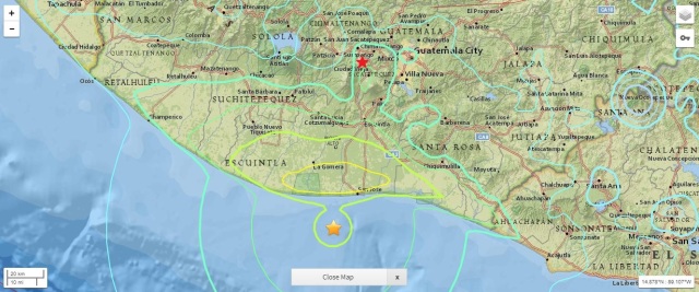
Map showing the amount of shaking form M 6.8 earthquake on July 22, 2017. Orange star is the epicenter, red star is Antigua, where we were staying.

Being a geologist who studies faults, once I knew we were all safe, I was so excited to have experienced my first earthquake. As you can see from the shake map, there’s something about Antigua’s location that made it experience more shaking than other places that are equal distances from the epicenter. While all earthquakes come with an element of surprise, there had been an M 6.9 earthquake in northern Guatemala about a week earlier, so we knew there had been recent tectonic activity in the region when we were headed down there. Looking through the earthquake catalog, I’ve noticed that there was in fact another earthquake the very next day after the one I experienced, an M 4.5 with an epicenter very near to the one the day before. A smaller earthquake following a large one is known as an aftershock– but I didn’t feel this one at all, and in fact hadn’t even realized it happened at all until looking at the USGS website now.

It is not a coincidence that Guatemala, home to many beautiful, active volcanoes (as you may have noticed from my pictures) is also affected by major earthquakes. The crust of the Pacific ocean is subducting underneath the American continent along most of the coast of Central and South America.

subzon_usgs

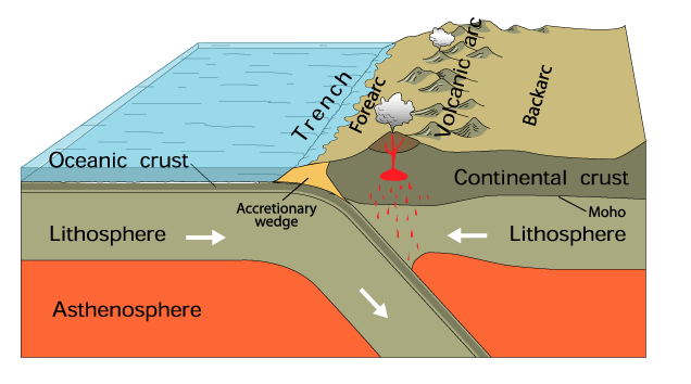
Cartoon of a subduction zone, from USGS.gov

As the oceanic crust drives below the continent, the surface where the plates meet and slip past each other (known as a “thrust fault” or “megathrust” in subduction)  produces large, deep earthquakes. As the oceanic crust pushes deeper under the surface, the heat and pressure at depth causes it to melt and rise up, resulting in the arc of volcanoes which make up the scenic background in most of my pictures from Guatemala. That is all I have to say for now, but please let me know if you have any questions about my trip to Guatemala or how subduction zones work!

IMG_20170623_182212177

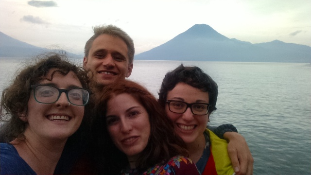
My friends and I in front of Lake Atitlan, with San Pedro volcano behind us

Posted in Uncategorized | Leave a comment

Art in science, and my anti-biology roots

One thing that I love about science is that in order to communicate one’s observations, it is sometimes necessary to make beautiful drawings. Artistic renderings haven’t been part of the research I’ve worked on myself and I am glad for that, because I am far short of professional artistic skills, but I do love to draw as a hobby, so I decided to share some of my recent sketches here.

34966112550_0e318cf112_o

Not-to-scale drawing of a Death’s-head hawkmoth.

Lately I’ve used drawing as a way to reconnect with the discipline of biology. I have been working as a gardener, and I am blown away on a daily basis by the amazing variety of plants that grow where I live (Western Massachusetts). There is an incredible amount to learn about all of these plants, but it is a pleasure every day to take it all in.

For a long time, I had a bias against the entire field of biology. I’ve come across this phenomena with other scientists I know too. It’s not always biology, but scientists (or students of science) sometimes have a tendency to become loyal to their own discipline(s) and develop a team-rivalry kind of mentality. I think there are many causes and expressions of this phenomena– some as simple as “I don’t understand that/I was never good at that,” but sometimes bearing greater condescension or disdain, e.g. “XYZ isn’t REAL science.”

33597877611_fc5ab3abd0_o

Drawing illustrating the anatomy and development stages of a mushroom. Do mushrooms have anatomy? I’m not sure. I should ask a Biologist.

A combination of factors culminated to make biology the science that I looked down on. I preferred math-centered sciences, where simple equations prescribed all the rules (obviously biologists DO use math and plenty of it, but my stubborn team-physics self didn’t think it was enough I guess, or the right kind, or some other silly hang up). I found biology confusing and messy and there was a seemingly endless amount of living phenomena to observe and somehow that seemed unscientific to me. I say all of this now not because I still believe it, but I know it is how I felt back then. By now I have fully reformed and have an immense respect for the discipline and I appreciate the many ways biologists tackles complex problems.

I suspect that the real reason I didn’t like biology for all those years may have been that I didn’t like my first biology teacher. I felt like she favored the boys. Her communication of the material was confusing. Her grading seemed arbitrary. And I sensed that she didn’t like me personally. It’s bee long enough that I can’t say for sure if this feeling I had was founded, I don’t remember any clear examples of what she did to make me feel that way. It seems ridiculous that one bad teacher (or maybe not even bad, but just not my cup of tea) could put me off to an entire field of study. I’m sure there are plenty of passionate biologists out there who wouldn’t or couldn’t have been dissuaded by one teacher they didn’t like, so it’s not that I think I was born to be a biologist and this teacher ruined it for me. I have, though, been heavily steered towards my current interests by excellent teachers, and inspired teaching has often been what drew me to the fields that I study and love.

On that note, inspired teaching seems like a good topic to explore more another day. That’s all of my thoughts for now. Please let me know what you think of this post– have you also experienced biases for/against certain sciences? Did you ever have a teacher that “ruined” a topic for you? Do you have any drawings you’d like to share? I’d love to hear from anyone who is reading!

Posted in Uncategorized | Leave a comment

I’m coming back…

…to the blogosphere. It’s been a couple years since I updated this blog. I’ve been out in the world trying on different professions, but I’m excited to share that I’m returning to geology and to school to pursue a PhD at UMass starting this fall. And that means I have science on my mind and things I’d like to share with you! I’ve already started to do background research for a project in Vancouver I may get involved with, so I’m planning to bring you some posts about paleomagnetism and the Baja-British Columbia controversy soon. I’ve also been thinking about science topics outside of geology (wild! I know! Who do I think I am?!). I’ve found a new love of biology recently, partly due to my current job as a gardener (there are soooo many plants you guys… soooo many). It’s also been a super exciting year for planetary science, with incredible images of Saturn and its moons and rings coming from Cassini, and spectacular Jupiter images coming from Juno. Yes, we have a lot to catch up on!

Posted in Uncategorized | Leave a comment